| |
Een Doelloos Blokje Om in 2008
Picture gallery and short trip report of a nine month continuous hike from the Netherlands through Great Britain and Norway.
|
|
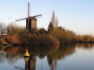
01. nl be fr [365 pictures]
|
Netherlands, Belgium, France (2 January - 6 February, 2008)
Starting on the first day of the year seemed like a good idea to me, however this was vetoed by the home front. So the start is a day later and I soon get back into the daily walkers rhythm. The first long distance path, the 7-Woudenpad, takes me south to Steenwijk in a few chilly days through the tree lined landscape of the Frisian 'Wouden' with no other problems than acquiring drinking water. I have a very stormy day along the river to Zwolle. It doesn't make walking much easier but it only lasts a day and the battle against the wind is strangely kind of fun. The following days crossing the Veluwe, a wooded region, are in contrast much quieter. Small winding paths and straight lanes through the forests and some open heathland bring me to Arnhem. Here I spent the first night in a hotel after 11 days camping wild. I worried a bit about the Airbornepad long distance path as it seemed to go from war monument to war monument and use a lot of tarmac while doing so, but this worry turned out to be unfounded though I did deviate from the route where it suited me. The Betuwe was crossed in a day. I did get to enjoy two apples donated by a friendly local of this famous fruit growing region. A day was spent in the woodlands south of Nijmegen. The next day was a very dark one indeed as I accidentally killed a pony. It was obviously not used to people with backpacks and jumped right through the fence from fright when I walked passed, impaling itself through the chest by one of the steel pipes from which the fence was built. I think it was over in a few seconds but I did rush to find the owner. He was not at home so the neighbours tracked him down. Luckily he was very understanding though he said his girlfriend was very emotional about it as she was a true horse lover.
Along some abandoned railroad before going further south following the pleasantly meandering Dommel through the city Eindhoven. South of Valkenswaard I changed track to the long distance path GR561 Kempen-Maaspad and crossed the border into Belgium. The relaxed building regulations here were very noticeable from the ribbon development of villages and the lack of a clear border between build-up area and countryside. Something else I vividly remember from Belgium is the very sticky mud on many unpaved paths which was probably not helped by the unstable weather. Other than that it was very nice walking in this country. I spent a night in an hotel in Diest before heading south-west along the GR512 Vlaams Brabant in a rolling landscape. A good sunny day is followed by a dismal rainy one on which I got lost several times. Onwards the route took me through two larger forests notable for their monoculture of beech trees with their bare trunks and lack of undergrowth. Must look even more impressive in the autumn. From St. Pieters-Leeuw to St. Kwintens-Lennik and on to Geraardsbergen in a more open landscape. It was busy on the paths as there were organised walks using the same route. Continuing on the E2 which runs together with the GR5A to Kemmelberg. A long day brings me into the wooded hills around desolate Ronse and L'Hoppe. Further on the route takes me along abandoned railroads near Avelchem before I unsuccessfully look for a hotel and camp in a bit of scrubland near a highway. Menen is a larger town so I spend the next night in a hotel. Not the best hotel I have ever been in, with the overflowing sewer of the upstairs neighbour and a somewhat meagre breakfast. Chilly wind and an abandoned canal bring me into the WWI front-lines. I reflect briefly on the amount of suffering and destruction mankind can accomplish with a bit of collective effort before crossing the next national border, into France on the GR128. Finding a place to pitch the tent gives trouble as the woodland on the map turns out to be a hops field and other options are fenced off with barbed wire and 'access interdit'-signs. A small secluded bit of woodland becomes home for the night but I'm rudely awoken in the morning by gunfire and I find myself practically surrounded by hunters meaning a hasty start. Over the Katsberg with its monastery and along a dismantled railway line. My guidebook is outdated and I (accidentally) cut off a long loop. I do manage to follow the new waymarking near Clairemarais and it turns out the new route makes a huge detour for no obvious reason. In the pictoresque town Cassel I get caught up in an organised walk and later in a carnival parade from which I hastily retreat. The undulating landscape turns more wooded after Watten. The weather turns from cold with frosty nights to changeable with long heavy rain showers and spells of clearer skies. Slippery muddy paths with strong winds and climbing over ridges slow me down a bit. The home front manages to scare me on my last night camping in France. My mother warns of illegal immigrants camping in the woods around Calais and I find myself staring at all the flickering lights in the dark. The next morning however it turns out I camped on a high spot and the lights were just street lamps shining through the trees. With the sea in sight I leave the GR128 and walk along the beach and dunes to Calais where I spend the night in a hotel. The next day I take the ferry to Dover.
|
|
|
|
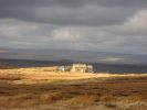
02. uk [892 pictures]
|
England (February 7 - March 29, 2008)
After collecting a stack of maps from the Dover post office I set off over the impressive white cliffs and under a blue sky and then turn inland on the North Downs Way. Good weather, wide views from the Downs and a very nice public footpath system make walking a pleasure. From Guildfort the E2 follows the River Wey and the Thames so I'm walking mostly on towpaths for the next week. Not really a great wilderness experience but I'm interested in the industrial heritage and the scenery constantly changes between rural meadows, woodland and more urban built-up areas so it never gets dull. The nights are getting colder with frost forming on the inside of the tent. I fail to find an affordable hotel or even a tourist information office in Reading but spend the night in a B&B in Tillehurst so my sleeping bag can at least dry a bit. The cold doesn't stay however, after a foggy day the weather turns changeable with some showers and sunshine. From Oxford I walk through rolling hills and quiet yellow sandstone villages along the Oxfordshire Way and the Heart of England Way. The next set of maps that I pick up in Alcester is missing the one that would have taken me around Birmingham so I decide to make for the big city for supplies and to recharge my phone, using towpaths along the canals through old industrial estates and staying in a cheap hotel. I'm impressed by the industrial heritage and the intricately interwoven infrastructure but depressed by all the shopping centres so I'm happy to leave noise and crowds behind me the next day. I rejoin the E2 at Lichfield and turn onto the Staffordshire Way in woodlands of Cannock Chase. I get distracted by abandoned railroads near Alton which turns into a detour past Cauldon Low. At Rudyard Reservoir the E2 turnes onto the Gritstone Trail and the scenery gets wilder with higher and steeper hills and deep forests. It also snows for the first time on this trip though some days later the weather turns to rain and wind. The map is not very clear on how the E2 from the Gritstone Trail connects to the Pennnine Way so from Lyme Park I make my own way to Kinder Scout. The change from rolling green hills to the bleak moors of the Pennines is pretty extreme. There are several fine days but also several days with almost continuous rain. Most memorable however is the ever present strong to stormy wind, there are even several instances of storm warnings on the radio. The desolate landscape combined with bad weather take a heavy toll on my mood. I arrive completely soaked at a B&B in Gargrave but are given a very warm welcome. However all the tasty home-made food leave me stranded for a day near Malham with indigestion and stomach cramps while I sit out another storm. Malham Cove and Pen-Y-Ghent form two memorable spots in days otherwise filled with rain or fog. A battle against wind and snow take me to the top of Great Shunner Fell but the weather turns peaceful and quiet at Tan Hill with its lonely pub. The only other walkers I meet on the popular Pennine Way seem to be day trippers to the hill tops. The walk through Teesdale is a pleasant change of scenery with some impressive waterfalls. Two days later I spend a day in the tent on the shoulder below Little Dun and Cross Fell sitting out a cold front passage that brings strong wind and so much heavy rain that the little burn next to the tent turns into raging 2 metre wide current. The next day brings snow in the Tyne Valley. I get a short vacation from walking by my visiting parents, who were also plagued by the wind during their ferry crossing. Goodbyes bring loneliness. Hadrians Wall forms the impressive backdrop for a day before turning north again across moors and through very dark and quiet forests with overcast skies and melting snow. The scenery along the Scottish border is impressive with high hills and deep valleys. Pitching the tent on a ridge on a quiet evening turns out to be a mistake however as the wind returns with a vengeance and fresh snow. I'm happy to reach Kirk Yetholm and so finish the Pennine Way.
Scotland (March 29 - 27 May, 2008)
Instead I'm pleased with the return of a more gentle landscape and a bit of sunshine for a few days on the St. Cuthbert's Way. In Melrose I finally leave the E2 as I head north on the Southern Upland Way to Lauder and then across more moors (with more rain and storm). A long days march but a blue sky on a bicycle path take me to Edinburgh where I spent two nights in a hotel. I say farewell to my old backpack, my dear companion during many years and trips and buy a new one. It turns out that I can take it easy for the next days as I have to wait for the next set of maps to arrive. So I visit Blackness Castle and the Bo'ness railway museum and then head west along the canal with the impressive Falkirk Wheel. I probably caught the flu in Edinburgh because I'm feeling very ill quite suddenly and spend two days in my tent. It doesn't matter much as the maps have not arrived yet at the Kirkintilloch post office and I can explore an abandoned hospital. Then I'm ready to enter the Highlands on the West Highland Way. A talkative Englishman accompanies me for half a day. It is nice to have a real conversation after being alone for many weeks but not something I want to do very often. The WHW is also the first time I encounter other long distance walkers. The going on this popular trail is easy, the weather (in general) nice and the backdrop of snowy mountains impressive so without much trouble I reach Fort William. Some money goes to a B&B here and more importantly to a new pair of boots before I set off again to Cape Wrath. Many sources claim I'm now entering the most remote and sparsely populated area of Great Britain but it never feels that way. Though there are rainy days with low morale it never gets as desolate and dreary as the Pennines. There are always other walkers, the spring weather is more pleasant and the landscape is more interesting with (sea) lochs to stare at, bothies to explore or take shelter in and peaks, ridges and navigational challenges to keep boredom away. Its a spooky start though, with rows of sheep skulls and a bright light on a hill top that turns out to be the full moon. At Strathan I tear my pants in an inconvenient place so I'm happy to carry spares. Loch Hourn impresses with exceptional beauty, helped by good weather. Past the Falls of Glomach the weather returns to rain so I have a rest day, though the next day to Strathcarron is not much better. Paths in the trail description have pretty much disappeared near Kinlochewe so the going is hard and I'm happy to find that the shop also opens on Sunday mornings. Another day with rain is spent on the shore of Lochan Fada. The view across the lake constantly changes from the changing natural light. After reaching Dundonnel I make my way to Ullapool but am told by a farmer that the ferry hasn't been operating for years which means a detour around Loch Broom and some road walking. I like my room in the B&B but not the food served at the fish and chip shop, nor the empty supermarket. The rain makes the walk through Glen Achall a trudge but the next day along the river Oykel is much better. I leave the prescribed trail a bit to follow the ridge from Ben More Assynt. It proves an interesting walk with spectacular views, an aircraft crash site and finally kilometres of loose rocks to cross. The sun really breaks through again in the evening at Kylesku. Some hot and sunny days follow and I get slightly sunburned but not nearly as bad as a ginger man I encounter at Sandwood Bay. It's a romantic place but also a bit too popular. The following day I reach another milestone called Cape Wrath. To Thurso I try to use as much tracks and paths as reasonably possible but many kilometres are trodden on the main road. After a night in a pleasant hotel in Thurso I take the ferry to the Orkneys and pitch my tent on its highest point on Hoy. The next day I visit the Scapa Flow museum and make my way to Kirkwall to board the ferry to Shetland. I don't see much of the Shetland Islands either. I take a small holiday from walking and stay close to Lerwick while futilely trying to hitch a ride to Norway as the ferry service has been cancelled the year before. Taking an airplane feels like cheating but in the end that turns out to be the only option. I take the boat back to Aberdeen, where I buy a new pair of hiking pants and fly to Bergen the day after. |
|
|
|
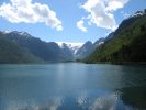
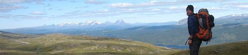
03. no [863 pictures]
|
Norway (28 May - 18 September, 2008)
The fresh stack of maps had just been sent back home but the people of the post office manage to intercept the package so with a days delay I am underway again. The fjord landscape is very impressive but also makes the hiking conditions extremely variable. I'm either walking on the road, climbing the steep wooded valley sides or plowing through snow on the fjell. Along the fjords the trees are green and the road verges and meadows are in bloom while 800 meters higher the mountains are still covered by endless snow fields. The amount of snow takes me by surprise and after the second walking day I have to pitch my tent on the only snow free spot behind a big boulder. The next day is mostly road walking, quite nice really with waterfalls, picturesque villages, lots of wild flowers and spectacular views across the fjords but I also loose my way. After a day in the tent because of intestinal problems I follow a narrow road back up to the fjell and walk across snow to Dale where I replace my smelly water bottle. The weather changes to sunny and warm. The walk in the next days seems to follow a sequence of road walking, path through woodland up the mountain, snow filled pass and than the same again in reverse order. I try to avoid continuous high paths because of the snow and find some alternatives, but I do meet some skiers at Norddalshytten. The weather turns bad and rainy for a few days. I have to wait a long time for the ferry across Sognefjorden and spend a day in the tent near Høyanger sitting out the rain, though the next day across the fjell is not much better. Good weather returns as I make my way along glaciers and deep fjords concluding with a ferry cruise to Geiranger. Another few days take me from an impressive valley over the snow covered mountain and back down in the lush green valley to a rainy Tafjord, once again repeated a day later though the path through Ulvådalen is a bit of a trudge. Through fresh snow showers up into the mountains again, ending with a fantastic view down into Eikesdal. Next day entails going down into the impressive Eikelsdal and climbing out of it again some kilometers further on. On these days with good weather it's very quiet in the mountains but later I descent into Litldalen to go shopping in Sunndalsøra which means a day of road walking. A heavy backpack has to be carried out of Sunndalen over the mountain to Innerdalen and then to Kårvatn. Either the holidays have started or this is a very popular hiking region as suddenly I encounter lots of other hikers. Mosquitos have gathered in force around Trollheimshytta so I don't mind getting out of the swampy valley and up Geithøtta which repays me with a beautiful panorama of the surrounding mountains. Having run out of petrol for my stove I cook my meal on an open fire for once. Ressfjellet is the final high peak I climb before crossing the more gentle rolling landscape on paved roads to Trondheim. After a night in a hotel, shopping and maps pickup I follow the coast of the Trondheimsfjorden east through villages and along some busy roads. In hindsight I could have used the Pelgrimsleden here. At Stjørdal I turn inland through long but ever narrowing valleys in a wooded landscape before first roads and then paths disappear and I find myself in a lonely landscape without any sign of human presence. At the lake Feren though is a large concentration of holiday cabins and also the start of more marked trails. Some days of regular heavy rain follow. I use the long days to walk in the evening after a rainy day. It turns out to be nice experience, the calm and low light giving the gentle landscape a whole different atmosphere. I make my way north along the Swedish border and then turn north-west to a trail head at Gaulstad for my parents to pick me up. This means a few rest days from walking and also a handy resupply. Revitalised I pick up were I left of. The marked trail ends at the Skjækerfjella and I need my GPS to find my way through thick fog across into Gaundalen. It's surprising to see how easy it is to stray off a heading in bad visibility. From the lonely working farm at Gaundalen the heading is north again following the old telephone line to Holderen and Gjevsjøn across rounded hills with views into Sweden. I manage to destroy my compass by catching myself during a fall while holding it. A landscape of bare smooth rock makes way for woods and wetland where it is hard not to lose a trail. I make some changes to my planned route. Firstly I trade several days worth of walking through not very interesting pathlessterrain for a day of road walking and secondly I decide to go through Sweden instead of the mountainous Børgefjell. This solves a resupply problem and also makes progress a bit faster. On the road from Lenglingen to Sandvika where I replace my broken compass and then to Gäddede in Sweden on two hot sunny days. Resupply here after exchanging money at the tourist office and on we go on the Swedish trail system. I see a familiar name (Ab Zijp) in the remnants of a guestbook in a cabin. The weather is generally calm and nice, the landscape not too spectacular with only a few rocky outcrops in between the rolling hills and birch trees. Not much of a trail but the red andreas crosses point the way. An abandoned mine is explored, crossing Balkesbuorke and the red Rödfjället. The paths are in good condition near Ankerede up to the waterfall Lejarälven which is probably a turn-around point for most people. After more woodland some nice wide views before reaching the somewhat dilapidated Klimpfjäll for fuel and a bit of shopping. I take the Norgefararleden back into Norway. This trail takes me through an imposing canyon in cold weather and later in more pleasant weather along a wide valley across the border. An emergency trouser repair before continuing north back on Norwegian trails, apparent from the wobbly hanging bridges. While crossing Rotvass the weather seems to suddenly turn much colder. A few days earlier I was swimming in lakes, now I'm back to wearing gloves and a hat. More good weather would return later but never very warm. A nice panorama and then descending into Skardmodalen. I have a bit of map trouble as the Swedish Fjällkart I'm using doesn't show the Norwegian trail. The backup Capellens road map does, but turnes out to be unreliable resulting in annoying hours of bush whacking while trying to find the trail. I decide not to resupply at Hattfjelldal which saves a detour of a day but does mean the food supply becomes tight. Fields of ripe blueberries help. Around the looming Spjeltfjell in the evening after a rainy day. Next day on the shores of Storakersvatnet has me feeling very tired and with two painful knees. I guess I caught some illness and I have to delay reaching Umbukta for a day. I hitch a ride to Mo i Rana for resupply, internet and a night in a B&B. Not the best of shopping expeditions since most shops and the library close at 15:00. Next day I hitch-hike back to Umbukta to enter the fjell again. It's been weeks since I saw other people on trail but now suddenly there are lots of other hikers. The weather is strange, rainy and windy days are mingled with very quiet and misty ones. One day is mostly spent walking on bare plains with marker stones and lonely cabins appearing in the mist. The sky clears after crossing the E6 and the polar circle and nature starts to show beautiful autumn colors. Bjøllådalen has many public mountain cabins and is also quite busy with other hikers. I follow the mountains north-west, camping high above the valley floor. Between threatening dark peaks I descent to another idyllic but also slightly claustrophobic camp. A long day on paved roads along maelstroms and around Saltfjorden to Bodø. Some shopping and the evening ferry to the dark peaks of the Lofoten rising from the sea. A rare stay at a campsite in Moskenes for a shower. On the Lofoten I have to connect marked and unmarked trails with stretches of road walking, including some under sea tunnels. I see hidden sandy beaches, wide views, and small fishing hamlets and in general a spectacular landscape. On the other hand off-road walking is hard, sometimes averaging only 1 km/hour. It is not helped by the map being optimistic on the existence of trails and the changeable weather. The problem is also with myself getting physically and mentally tired of walking and the general hardships of outdoor life. I decide to stop at Narvik and not to continue on my never really decided upon plan to walk the whole way back via Finland and the Baltic. Resupply after a late arrival in Svolvær. Next is the new E10 and the ferry to Møysalen National Park with more impressive scenery and hard going trails. The trail across Hinnøya is also beautiful and also easier. Across the bridge from Lofoten to Ofoten and a well deserved stay in a motel. Detour to Evenskjer for supplies. In essence there is just one continuous trail along the length of the Ofoten peninsula. From golden woodland it slowly climbs higher and gets wilder across the mountains. For a change I spend a cosy night in Blåvatnhytta getting out of the cold rain. Past Skoddeberghutta the trail disappears in a long stretch of birch woodland. The next day I reach the E6 at Øse. I can't find the continuation of the trail on the other side of the road, which is not helped by a missing map. I walk down the road to Bjerkvik and somewhat reluctantly decide to call it quits. I hitch a ride to Narvik where the campsite has already closed for the season. I spend a night in a pension and buy a plane ticket for next week. This gives me the time for a last couple of days in the wilderness, taking the bus back to Bjerkvik and walking through beautiful autumn colours in perfect weather to Katterat station. I take it easy and enjoy nature and the industrial heritage of the railway line. A train takes me back again to Narvik with a stay in the hostel to clean up. A combination of bus, airplanes and a train makes up the home journey. In Leeuwarden I'm refused water and at night during the last wild camp I note I have to get used to all the noise from people and traffic again.
Total travel time: 261 days
Nights spend:
in Hotel, B&B, etc.: 22
in a mountain hut: 1
in the tent on an official campsite: 6
wild camping: 231
Walked distance: +- 4900 km
|
|
|
Gallery generated by SPGM |
|
|